Writing excerpt from M.S.Arch thesis project The Line of Light: Sensing at the Brink of Sensibility (2023), advised by Zulaikha Ayub.
Introduction
We are surrounded by light and energy: from visible light to a vast spectrum of radiation, electromagnetic waves permeate the space around us, continuously traveling and transmitting energy. Most of these waves are invisible to the human eye, yet they enable us to perceive beyond human sensorium, mediating between sensors and unseen matter, as though communicating in a different dimension. Modern technologies rely on these invisible energy transmissions, as exemplified by the ubiquitous integration of satellite communication from transportation and geolocation to information and data management. While the satellites orbit the Earth each at a different distance and direction, tethered by Earth’s gravity, together they form a network so efficient that we rely on it for reference constantly. This reliance marks a shift in systems of sensing—particularly in the frameworks of perception and measurement—from tangible to abstract. This phenomenon challenges the notion of terrestrial territory and prompts a new Copernican inquiry into the situation of Earth and our situation within it.
The project consists of a series of investigations into digital Earth-sensing systems and their methodologies through various means of representation. By interrogating instances where numerical binaries draw boundaries, where systems are formalized, or where transformations occur, it seeks to reveal the disjunction between human sensorium and technological sensing, and to further delineate the underlying power structures that sustain these sensing systems.
Lineage
From the launch of Sputnik to the moon landing, space expeditions have been instrumental in advancing society. Like aviation, material science, information technology, innumerable industries carry forward the legacy of space technology, shaped by a shared ideology from the space age—to transcend beyond earthly conditions. Meanwhile, our vision of Earth continues to evolve with each new discovery. Photographs of Earth taken onboard Apollo missions highlight the dual nature of our space aspirations: not only to journey outward and explore but also to look back at Earth from afar. Rising beyond gravity’s pull, these vessels of transcendence alleviate the weight of the human condition.
Universe and Universality
Standardized systems of measurement are integral in every fields of science, providing a common language that facilitates understanding, precision, and interoperability across diverse disciplines and societies. The origins of standardized measurement systems trace back to the 18th century, with units initially defined based on Earth’s properties—the meter corresponding to the size of the Earth, and the second to the Earth’s rotation period. Traditional definitions of length, weight, and time interval are adequate for daily use, where local contexts and familiar scales suffice. However, when measuring phenomena on planetary, interstellar, or cosmic scales, these definitions fall short, revealing a realm where familiar units struggle to fully capture the vastness or complexity involved. The universe itself challenges the assumed universality of measurement systems to which our sensibilities have been attuned; we hesitate to draw the line.
From Earth to Atom
Building on the Earth-based conventions, standardized measurement systems continue to evolve. In 1960, The International System of Units (SI) was established by the General Conference on Weights and Measures (CGPM), an international organization created by the Treaty of the Meter in 1875. The formalization of the International System of Units in 1960 aimed to create a coherent and universally accepted system based on seven base units, including meter, second, and kilogram. In contrast to the previous reliance on Earth as a reference, these units are now defined based on constants derived from microscopic or invisible phenomena—such as the speed of light, the transition frequency of the cesium atom, and the energy of a photon. These constants allow for the definition of units that remain unaffected by external factors, such as Earth’s magnetic field and other variable physical conditions.
The Line of Light
A more precise term for this light-measuring instrument would be “the electromagnetic spectrum,” which encompasses all forms of radiation across an infinite range of wavelengths. The speed of light, defined as 299,792,458 meters per second by the SI, marks the boundary of our sensing capacity. All electromagnetic radiation travels at this constant speed. Adopted as a fundamental constant by the SI, the speed of light serves as the sole reference for defining speed, and subsequently other SI units. Light is the ultimate unit of measurement.
Edge of the World
Lines on a map delineate land from ocean, marking the boundary of habitable terrain. Early world maps also introduced the distinction between known and unknown territories. Eratosthenes’ Map of the Known World encapsulates land spanning between the continents of Europe, Asia, and Africa, along with surrounding islands. The “known” world is enclosed by oceans, beyond which lie territories that remain unexplored and unknown. In early cartography, the ocean often implies the extent of the known world, highlighting limitations due to physical constraints and signifying a mode of knowing of the world through exploration.
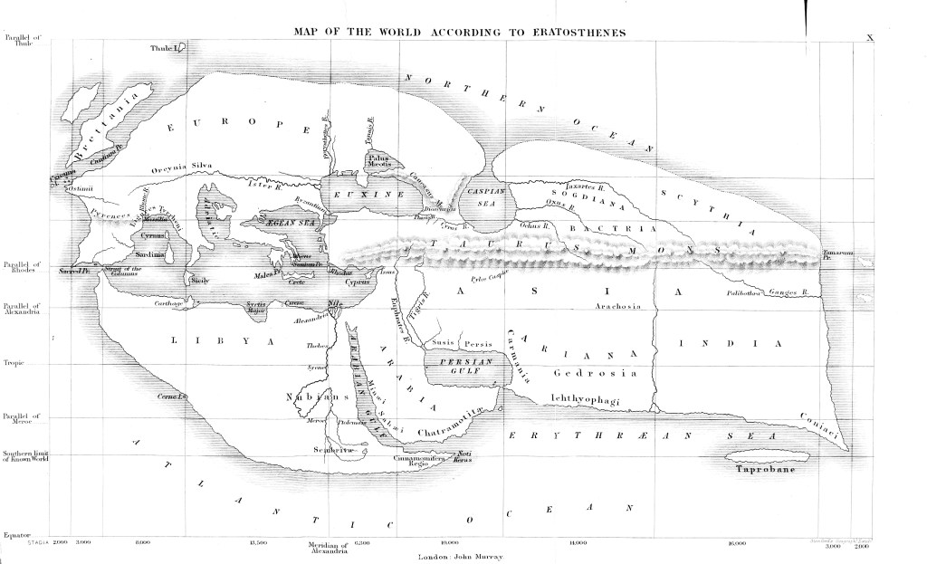
Fig. 1 Eratosthenes’ map of the known world.
Advancements in maritime expeditions transcended these limitations. Coastlines evolved from barriers into points of departure and reference, a shift reflected in the use of Portolan charts for navigation. In addition to charts, astronavigation tools like the sextant were employed, allowing navigators to calculate their position at sea by using celestial bodies and the horizon as references. The observer, the celestial body, and the horizon together establish a structure of observation—through sighting, measurement, and calculation, the observer can determine their position on Earth through the relative situations of the three. While at the edge of land, the horizon terminates at sea, marking the limit of sight; at sea, it serves as the baseline for other modes of knowing, particularly geolocation in early navigation. The boundaries of knowable territory expanded to encompass the entire surface of the globe.
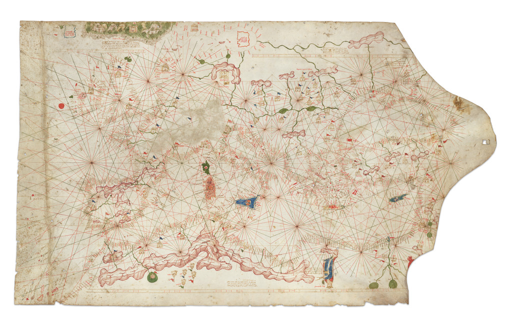
Fig. 2 King-Hamy Portolan Chart, c. 1502.
Then, against the line of gravity, humankind transcended into space, thereby surpassing the limitations and necessity of the horizon. Earth, once regarded as “the world” in its entirety before the space age, began to be perceived as a solitary object, floating within the vast expanse of the universe. From a distance of about 18,000 miles from Earth, the famous Blue Marble photograph was captured by the crew of Apollo 17, which renders the world as a luminous object, distinctly separated from the black background of the universe by a circular outline.
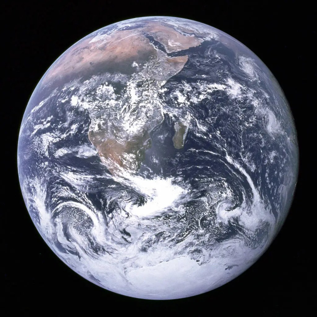
Fig. 3 The Blue Marble, 1972.
The separation between Earth and the universe, however, consists of thousands of miles of atmosphere; in fact, no clear boundary between Earth and outer space is drawn. An attempt to identify this boundary is the concept of the Kármán line, defined as an altitude of 100 kilometers above mean sea level. The Kármán line serves as a widely accepted boundary between Earth’s atmosphere and outer space, which is crucial for regulatory and scientific purposes. Following the rapid technological advancements of the Space Age, outer space became increasingly populated with artificial satellites and spacecraft. Alongside international space law, such as the Outer Space Treaty, the Kármán line carries significant political implications, as it delineates the domain where the concept of terrestrial territory, marked by borders, ceases to apply.
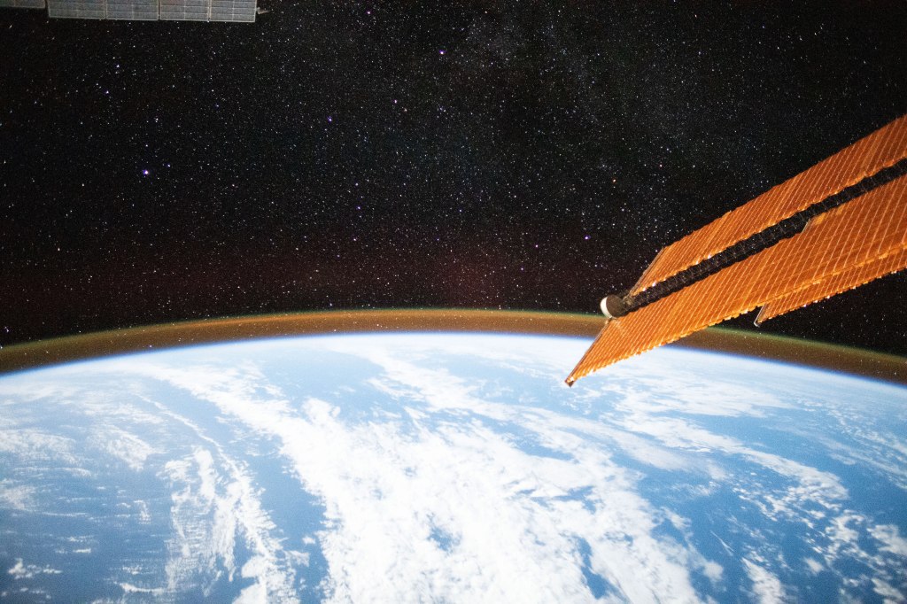
Fig. 4 Airglow roughly indicating the altitude of the Kármán line.
Edge of Knowing
Stemming from the synthesis of sensing and make-sensing of the sensory experience, knowledge is closely linked to the acts of observing and thinking. Plato’s allegory of the cave illustrates these stages of knowing in relation to the observer’s different modes of interaction with the subjects. Plato also derived a model that situates the stages of knowing along a line, forming the analogy of the divided line. The line—divided into four segments, each representing a level of cognition—symbolizes the progression from illusion to true knowledge.
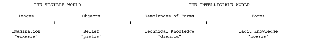
Fig. 5 Plato’s analogy of the divided line.
Deleuze offers another framework—the plane of immanence—as a way to contextualize reality and knowledge. Deleuze’s plane of immanence is non-hierarchical and boundless, where all ideas, perceptions, and becomings coexist without any transcendental truths. With no separation between the material and the abstract, it operates as a zone where knowledge and existence are fluid, interconnected, and emergent, rather than ascending along a linear continuum toward an ideal. Deleuze, along with Guattari, further developed the idea of multiplicity in contrast to traditional notions of unity. Multiplicity fosters a more nuanced understanding of knowledge and truth, unrestricted by an absolute continuum. It operates within a domain established by the abstract line—the line of flight. At the brink of multiplicity, the line of flight is the agent of transformation and a means of escape from the established structures of consistency and unity.
The influence of multiplicity is evident in other disciplines of science, especially in the transition from classical to quantum physics. Quantum theory presents, with scientific evidence, a reality that defies a simple separation of subject and object or observer and observed, through principles of quantum mechanics like superposition. Knowledge, therefore, is neither absolute nor final but rather a process of continuous becoming—echoing how quantum observations reveal only partial truths shaped by context, interaction, and observation.
Edge of Sensing
Technological apparatuses extend our sensing abilities beyond physical distances and the range of human perceptibility. With the implementation of remote sensing technology and global telecommunication, sensing now takes place at a planetary scale. These processes of data collection and transmission rely on a wide spectrum of electromagnetic waves. In principle, all electromagnetic waves travel at the speed of light—a fundamental physical constant that governs the behavior of all matter and energy.
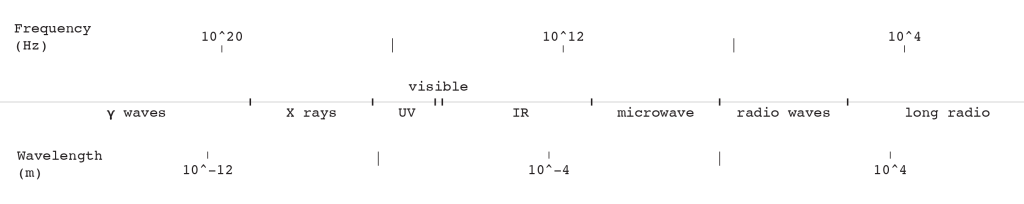
Fig. 6 The electromagnetic spectrum.
Along this spectrum, each sensing system is calibrated to detect and interpret signals within a specific frequency range, with a specific level of sensitivity. Beyond this range, signals are unobservable to the system. Furthermore, the behavior of electromagnetic waves varies based on the properties of the matter they interact with. Just as visible light cannot penetrate solid objects, each type of wave has its own limitations. These limitations determine the extent to which the waves can travel through different substances and how effectively they can transmit information or energy.
Form-Becoming
Captured by sensors and processed through computational systems, intangible phenomena are transformed into visible, perceptible, communicable, or “utterable” forms. Whether through visualization or analysis, these phenomena are articulated using specific techniques, which in turn shape the forms they take. Digital binary computations and quantitative functions serve as the foundational syntax persistent throughout the manifestation of forms. These technologies shape how information is represented visually, establishing a framework through which complex data sets can be translated into meaningful, legible outputs. The legacy of the Apollo missions and their Earth photographs has significantly influenced the visual aesthetics of such representations, embedding a distinctive visual language into the ways we interpret the planet.
Furthermore, satellite telecommunications allow information dissemination to take place at a planetary scale through mass media, adding another dimension to the process by amplifying and spreading these visual representations across global networks. The circulation of Earth imagery through print, television, and digital platforms has popularized a specific visual language that not only informs but also shapes public perception of the planet. The convergence of space exploration, digital computation, and mass media creates a multi-layered process that mediates our perception of the world in both scientific and symbolic terms.
Sense-Becoming
The scale of sensing enabled by artificial apparatuses has transformed the concept of experience from individual into collective, from local to global. In the age of information, telecommunications and broadcasting have significantly shaped our senses and, consequently, our memory and logic. The concept of “event” assumes a fundamentally different nature in the context of mass media. In traditional contexts, an event may have been understood as a singular occurrence with a direct impact on the individuals involved. This definition is, however, challenged by Deleuze and Boundas, who argue that events are not merely isolated occurrences but rather complex phenomena. Events produce “sense”—a dynamic interplay of meanings and interpretations that are continually shaped and reshaped through discourse, experience, and perception. In the context of mass media, events are mediated in multiple dimensions, such as spatial and temporal, and disseminated to a broader audience, altering their significance and implications. The threshold of “becoming” for events, or “eventhood,” is also greatly challenged: events are no longer straightforward transitions; they are continuously mediated and recontextualized, leading to a blurred definition of what constitutes an event.
The impact of events on collective consciousness is a pivotal aspect of understanding how we perceive and interpret the world, as mass media transforms the sensing of events into a collective phenomenon. McLuhan’s notion of “the medium is the message” highlights that the characteristics of the medium—be it television, print, or internet—determine the nature of engagement and discourse, as well as the collective memory constructed around these events. An event such as the moon landing can represent, on one hand, a shared memory for an entire generation worldwide; on the other hand, it can also be viewed as a narrative constructed from low-resolution visuals. This duality reflects the complexities of how events are interpreted and remembered in the age of media, where the blending of reality and representation complicates our senses.
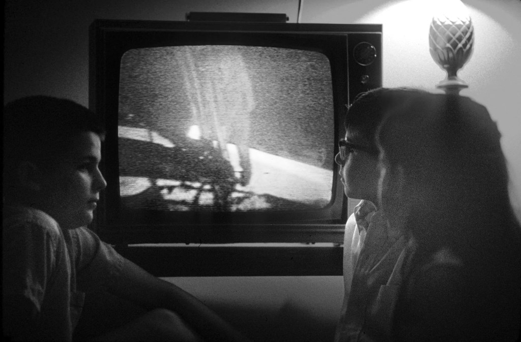
Fig. 7 “Kids watch as Neil Armstrong steps onto the moon.”
Conclusion
Our understanding of the world is entangled with technological, scientific, cultural, and philosophical influences. From terrestrial expeditions to satellite networks, our modes of world-sensing have evolved to transcend physical and conceptual boundaries. The line between the visible and invisible, the intelligible and unintelligible, are continuously negotiated through these technologies. The line, as a symbol for both definition and measurement, abstraction and transformation, becomes an omnipresent force that shapes and defines our interactions with the world, despite being devoid of agency. It serves as a constant through which we quantify, define, and organize our perceptions, yet embodying no intent or volition itself. As a tool of precision and simplification, the line captures the essence of our ability to measure and navigate reality, marking the thresholds between states of being and transmitting information across different dimensions. By delineating the evolution of Earth-sensing systems through a series of lines, the project aims to prompt a deeper reflection on the underlying power structures and ideologies that govern or challenge our collective sensibility.
Bibliography
Literature
Bennington, Geoffrey. “In the event.” In Derrida’s Legacies: Literature and Philosophy, edited by Simon Glendinning and Robert Eaglestone. Routledge, 2008.
Bohm, David. “A Suggested Interpretation of the Quantum Theory in Terms of ‘Hidden’ Variables. I.” Physical Review 85, no. 2 (January 15, 1952): 166–79. https://doi.org/10.1103/physrev.85.166.
Bunbury, E.H. A History of Ancient Geography among the Greeks and Romans from the Earliest Ages till the Fall of the Roman Empire. London: John Murray, 1883.
Deleuze, Gilles, and Félix Guattari. A Thousand Plateaus: Capitalism and Schizophrenia. University of Minnesota Press, 1987.
Deleuze, Gilles. “Dispositif (Apparatus).” In The Cambridge Foucault Lexicon, edited by Leonard Lawlor and John Nale. Cambridge University Press, 2014.
Deleuze, Gilles, and Constantin V. Boundas. The Logic of Sense. Columbia University Press, 1990.
Fédération Aéronautique Internationale. “100km altitude boundary for astronautics,” December 28, 2020. https://www.fai.org/page/icare-boundary.
Foucault, Michel. The Archaeology of Knowledge: And the Discourse on Language. Vintage, 1972.
Plato. Republic. Oxford University Press, 2008.
Plato. Theaetetus. Oxford University Press, 2014.
Schrödinger, E. “Quantisierung Als Eigenwertproblem.” Annalen Der Physik 384, no. 4 (January 1, 1926): 361–76. https://doi.org/10.1002/andp.19263840404.
Media
Dettmar, Kevin. “Witnessing the Moon Landing in Ireland, at the Start of the Troubles.” The New Yorker, July 20, 2019. https://www.newyorker.com/culture/culture-desk/witnessing-the-moon-landing-in-ireland-at-the-start-of-the-troubles.
King-Hamy Portolan Chart, c. 1502. HM 45. The Huntington Library, San Marino, California. https://catalog.huntington.org/record=b1842787.
NASA Earth Observatory. “Airglow Over the Indian Ocean,” October 8, 2020. https://earthobservatory.nasa.gov/images/147367/airglow-over-the-indian-ocean.
NASA. “Blue Marble – Image of the Earth From Apollo 17,” November 30, 2007. https://www.nasa.gov/image-article/blue-marble-image-of-earth-from-apollo-17.
The New York Times. “The Apollo 11 Mission Was Also a Global Media Sensation,” July 15, 2019. https://www.nytimes.com/2019/07/15/business/media/apollo-11-television-media.html.
